
Channeling Jack's Ghost
May 2017
A young Shawnee Indian boy stowed away on a packet steamer headed down the Ohio River in 1811. As the boat reached the Mississippi and started south, the New Madrid Earthquake turned the waters backward and wrecked the steamer, pinning the captain in the wreckage. The boy, nicknamed Jack, freed the captain, and for the kid’s bravery, the skipper gave his captain’s cap to Jack.
After a career on the Ohio and Mississippi rivers, Captain Jack settled along the river that eventually took his name: the Jacks Fork. Always wearing his cap, Jack became a fixture on the river. For decades, day and night, summer and winter, he poled his john boat up and down the river. He was a bit mysterious, but he looked official in his captain’s hat.
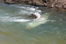
Today Jack’s spirit warns floaters, even experienced floaters, that this river—any river—can be tricky.
They’re about to become trickier.
Come mid-summer, floaters may lose a key river tool. The tool isn’t something you buy at the Jiffymart with beer and snacks.
It’s a gauge—one of 49 gauges that measure our rivers in key spots. These gauges—operated by the United States Geological Service—have saved countless lives by reporting water volume and river levels to your smart phone. Smart floaters use these gauges. Combined with weather forecasts, the gauges can help plan a safer experience on the river and help avoid high-water tragedy and low-water trudgery. Gauges inform floaters on the Current River, the Jacks Fork, Eleven Point, Meramec, Huzzah, Little Piney and the Big and Little Niangua Rivers.
Avoiding float trip tragedy is only one purpose for these stream gauges. Beyond these Ozark float streams, the same type gauges are on many rivers for a different reason. They provide data for managing drinking water and timing wastewater discharges and reservoir releases, irrigation, even power plants. They’re used to manage habitat. They help design bridges and levees and dams.
But current funding for these 49 USGS gauges in Missouri will end June 30. Unless other funding sources are identified, the information from these gauges will no longer be available.
If you’re a Navy Seal, you probably feel secure without these reports. If you’re a mother sending your kid into the unknown, you may not be so sure.
Figures from the USGS indicate that one gauge costs about $15,000 to operate for a year. If a gauge is removed a re-install would add about $15,000.
Writer, geologist and hydrology expert Jo Schaper compares “rivers without gauging stations to roads without traffic signals. You could still use the roads, but the risk would be much greater.”
Former Missouri Department of Natural Resources Environmental Specialist Sharon Clifford brings up another issue. As MDNR’s first coordinator to monitor our streams’ Total Daily Maximum Loads, Clifford recalls that “40 states were sued over this issue. It’s about fixing waterways that don’t meet standards after all permits are issued, and it’s part of the Clean Water Act. To calculate a TMDL, you must have good flow information to plug into the model. Without it, it isn’t possible to do it accurately. So what now? More lawsuits? Huge waste of tax payer dollars.”
It’s like driving a car without a gas gauge.
Your mechanic has a phrase for it: “You can pay me now, or you can pay me later.”
Listen to your mechanic. Contact your state and federal representatives and tell them to keep the river gauges.
It might save a soul from joining the ghost of Captain Jack.
Read more of the author’s stories at JohnDrakeRobinson.com. His previous books, Coastal Missouri and A Road Trip Into America’s Hidden Heart are available at independent bookstores and online booksellers everywhere.